Hiking the Bruce Trail End to End – Part 10
Part 10 – 6th Sideroad to 9th Sideroad– 459.4/890km
Part 10 was a weekend hike.
Saturday, May 10, 2025 – 52.6km Blue Mountains section-8.4km Beaver Valley section
This was the first BT hike for this year and it didn’t go as planned at all. My mom had torn something in her calf back in March and by the beginning of May it still was not healed, so we made the decision for me to do this hike on my own and when my mom gets back from her trip in July she will do this section of the trail with friends, so we will be able to continue on together for the next part of the hike at the end of August. There were just no available weekends for us to do this together in July or early August.
Luckily my partner was originally going to come up with us and stay the night at the hotel, so I wouldn’t be completely alone and he would be close by during the hike (who does not hike). We left around 6:30am and drove up to the north entrance of the Pretty River Valley Provincial Park on 6th Sideroad. We got there around 8:15am and I started hiking at 8:20am. A little later than I should have, but our starting points are getting further and further away. It was nice and sunny out, a bit cool but warm in the sun – in short perfect hiking weather! I started off along the unimproved road to the end and then headed off into the new trail which skirts Osler Bluff. Some big rocks and karsty bits, but the trilliums were in the full bloom in the forest and it was gorgeous! I even saw several red trilliums!


At 9am, I crossed a dirt road into the Petun Conservation Area, which has a fairly flat trail through the forest. I ended up seeing something that looked like a marten but was a but bigger. Not entirely sure what it was as it scurried away as I got closer. You’ll then descend some rocky bits and pop out onto 2nd Line. Crossing over the road you’ll head back into the forest and end up at the bottom of a little cliff. There was snow still in the crevices here. You have to do a bit of a scramble to get up and over the ledge, but once that’s done it’s a pretty flat trail through the trees.


I came to an unimproved dirt road around 10am and followed it along until it emerged onto 3rd Line, passing some houses and then turning onto the busy New Mountain Road with some magnificent views of Georgian Bay in the distance. You’ll continue along the side of the road for awhile, passing the Castle Glen Estates. At 10:30am I came to a small parking area and followed the trail that led into the woods. It heads downwards to cross a stream and a rushing river a little further on before a steep ascent. It then continued into a bit of a clearing with another little stream to cross. There were lovely marsh marigolds in bloom here. You’ll continue up, crossing a clearing for power lines with a views towards the water before emerging onto 12 Sideroad, which I did around 11:10am.


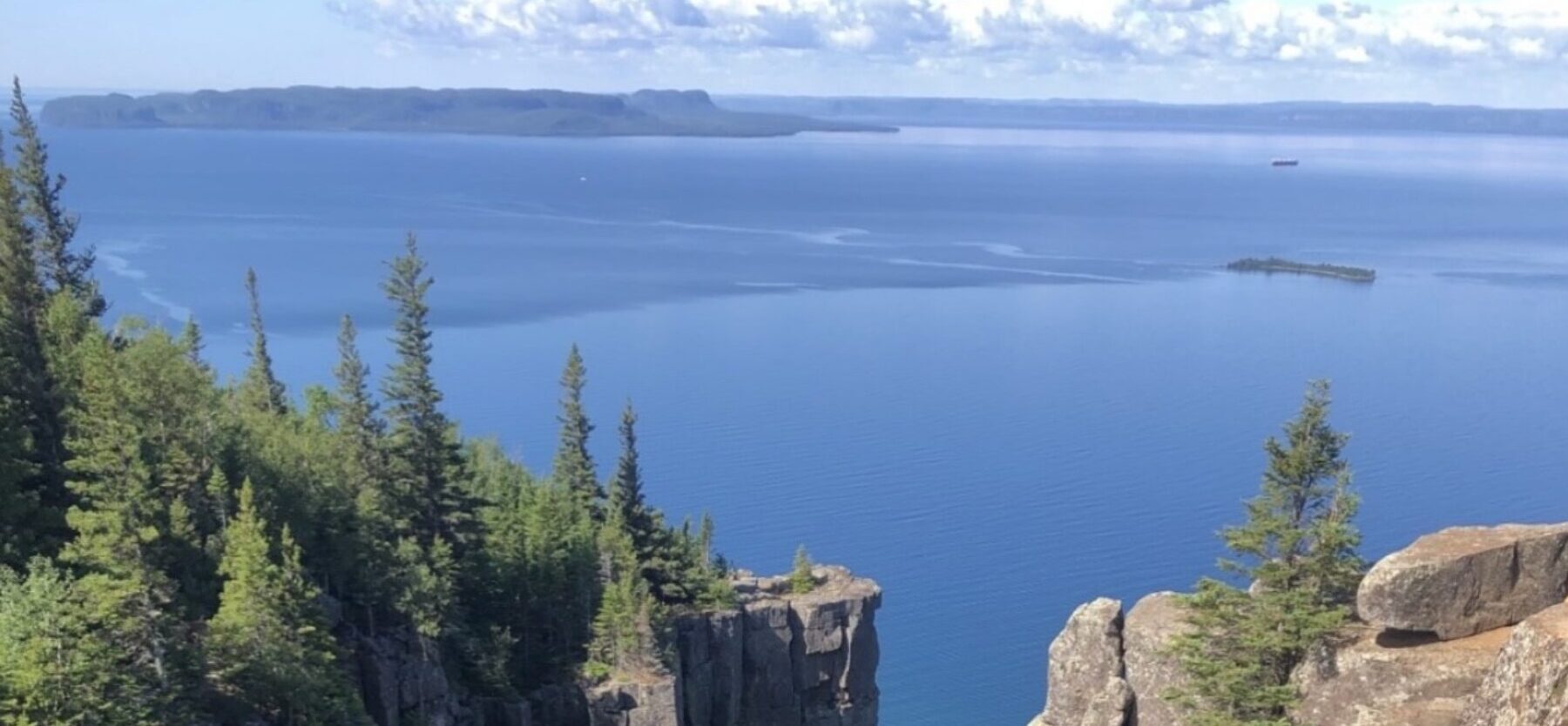
Crossing the road, you’ll then head over the fence into the Scenic Caves Property, which is closed from November 1 to May 1. You’ll head through a field, up some rocky hill and then the paths are fairly wide and level throughout the property as they’re used for snowshoeing and cross country skiing in winter. You’ll follow along a dirt road skirting farm land and start seeing some houses before exiting the property and turning right onto Scenic Caves Road, which has a lovely view of the water. Shortly after you’ll turn into the trees and end up on a dead end dirt ad which connects with Scenic Caves Road again near the Blue Mountain parking lot. Entering into the parking area on the right, there is a great view of the Blue Mountain ski hill, village and the Bay. There is also a sign marking the halfway point between Tobermory and Niagara (446km each way). There are also several plaques describing the history of the area and Blue Mountain and the remains of Ontario’s first chairlift.


I stopped here and sat on a large rock to have lunch around 12:30pm. I was not making good time, and realized I’d likely not get as far today as I would have liked. I had been very ill about a month ago, not sure with what and I think I was still pretty weak from it, as I didn’t have much energy and was pretty tired. But I just went slowly and did what I could. The most amazing thing was that my plantar fasciitis didn’t bother one bit the entire weekend! That’s the first time in two years!
After having a quick lunch I started off again along the path skirting Scenic Caves Road, and then the parking lot along Swiss Meadows Blvd. You’ll continue along past the Blue Mountain chairlifts, with an amazing view over the Bay along this section. The leaves on the trees were just starting to bud, so I imagine when they’re fully out, it blocks most of the view. You’ll continue down along the side of the mountain through the forest, crossing a stream or two, and then there’s a steep climb up to the top of the ridge again where you’ll pop out into a lovely little subdivision. It is here that the boundary between the Blue Mountain section and the Beaver Valley section is located. I got here around 1:20pm.
You’ll continue along Maple Lane past the subdivision away from the clifftop, and then turn into a path at the end of the road which leads you through a farm field. I saw a deer and two fawns running into the trees as I was approaching the woods at the far side. Once in the woods, you’ll skirt the top of the bluff with views of the water peaking through. You’ll pass a couple more chairlifts before heading into a smaller, uneven trail through the woods. There is a very steep descent here with stairs and a rope handrail. You’ll cross a stream at the bottom of it before again heading back up steeply. Emerging from the trees, you’ll come to a clearing with a wonderful view of the Bay and a lovely bench upon which to rest. I got here around 2:30pm. This spot is at km 3.6 of the Beaver Valley section. I had wanted to originally go to 11.3km, but was fading fast, so told my partner to meet me in a couple of hours at the 8.4km point.


Leaving the lookout, you’ll head steeply down the hill again, across a stream, through a clearing and again back up a very steep hill. There are some lovely rock formations at the top and I saw people walking their dogs, which indicated to me I must now be in the Loree Forest. The paths are relatively flat and wide and skirt the bluff. At one point you’ll come to a clearing with a chairlift belonging to the Georgian Peaks Club which has a lovely viewing platform with benches. I got here around 3:30pm and then slowly made my way through the forest, past a field, again back into the trees, before heading steeply down the hill, passing a lovely stream and again making a steep ascent, which led to 21st Sideroad and the end of today’s hike. My partner picked me up about five minutes later and we drove to the Blue Mountain Resort to check into our hotel.


We ended up staying in the Weider Lodge, which was nice, although the underground parking, which is only available to hotel guests is not included in the price and is an extra $20/day, which seems like a bit of a rip off. This was the first time hiking the BT where my feet were not in agony at the end of the day due to my plantar fasciitis and it was amazing to actually be able to walk around! I went to the convenience store and got some water, then we headed out to Mylar and Loretta’s restaurant in Singhampton about 30 minutes away for dinner. It was very busy, being Mother’s Day weekend and all but we eventually got seated around 7:20pm. I got the French onion soup, which was very good, as well as the schnitzel parmesan. We got back to the hotel around 9pm and I went to sleep shortly after that.


Sunday, May 11, 2025 – 8.4km-33.3km Beaver Valley section
I got up at 5:30am and got ready. I had brought some boiled eggs with me so had those for breakfast. My partner drove me to the starting point and I started hiking around 6:30am. It was a bit cool out but nice and sunny, and it warmed up as the day progressed. You’ll start off heading into the trees on the side of the road and crossing a stream before heading over a style into a lovely field. Passing another style, you’ll head back into the trees, crossing another stream before heading steeply up a hill. At the top is a bench. You’ll continue on beside a field before it turns into an unimproved road, passing some lovely houses before joining up with 18th Sideroad. Here you’ll turn right and continue along the road past farms and houses until the end of the road where you’ll again head into the woods. Exiting the woods, you’ll pass through fields before crossing a stream and again entering the trees. You’ll follow a lovely clear stream with little waterfalls at this point. There is a bench here where I rested to put a band aid on a large blister that had just sprung up on my heel and was very painful. But I’ll take a blister over plantar fasciitis any day!


You’ll continue along through the forest, skirting the top of a waterfall. There wasn’t much water but a lot of the rocks along the ledge had broken away into the gorge. You’ll continue downhill before crossing another lovely stream, making a steep ascent before popping out onto 6th Line. I got here around 8:10am and it continues up steeply before joining the 119, which passes lovely farms and houses with magnificent views over the water. You’ll continue along this road for awhile before popping off into the side and skiting some farm fields. There was a lovely little boardwalk here with some marsh marigolds, and then you’ll enter the lovely woods of the Skeoch Nature Reserve. There were carpets of trilliums and lovely little caves and karsty bits along the side of the trail. You’ll then continue on through a clearing before entering the trees again and walking beside the most lovely river, which has a nice bench overlooking it. Crossing the river a little further on, then end pop out into a farm field which leads to 12th Sideroad. You’ll follow the dirt road past a lovely barn before again heading into the trees which skirt more farm fields. There are number of styles here between the fields you’ll have to climb over, and then head upwards through the woods. There is again a bench at the top a sign indicating that this section of the trail was once the Old Mail Road. Once through the woods, you’ll skirt another field, and then enter another field which has a number of cows grazing at the far end. Climbing over a few more styles, you’ll continue through the front field and emerge onto the busy Hwy 19. I got here around 11am.


Crossing the road, you’ll continue on the other side skirting another field before heading into the woods. The paths here were quite flat and easy to walk along. You’ll eventually emerge into another field which has two benches with lovely views! I give full points to the Beaver Valley section for benches! After a little ways more, you’ll emerge onto Hwy 2. Crossing the road, you’ll go through more farm fields, there were horses and cows here, before heading into the woods again. Eventually you’ll pass a couple more fields before stumbling upon some amazing lookouts from the top of Metcalfe Rock. I hadn’t really encountered anyone else along the trail but this area was relatively busy with hikers and people climbing the cliffside. Making a steep descent down the rocky terrain to the bottom of Metcalfe Rock, you’ll pass the entrance to the Metcalfe Crevice Side Trail. Although only 300m, it looked like a lot of scrambling, and as I was alone, tired with blistered feet, I opted to skip it and return on a later hike to do it justice.


You’ll then continue through the trees before popping out onto 10th Sideroad. I crossed here around 1:15pm and continued on through the field and into the woods on the other side. You’ll skirt the valley before eventually making a very steep descent and crossing Mill Creek on a newly built bridge with lovely benches built into it. I stopped here around 1:45pm to have a quick lunch before continuing on and making a very steep ascent up the other side. Once at the top it levels out and you get some great views of Metcalfe Rock back across the valley. Continuing on, you’ll cross another stream and then skirt a field with a view of 6th Sideroad in the distance before heading again into the woods and crossing a stream above it’s waterfall. Again there’s a steep ascent up the hillside, past some lovely rock formations, at which point you’ve entered the Duncan Crevice Caves Provincial Nature Reserve. I got here around 2:45pm and was getting very tired. My pace was very slow this weekend so I didn’t get as far as I had planned. Instead of going to 39.3km, I decided to stop at 33.3km at the parking lot at the entrance to the Duncan Crevice Caves. I had about 2km left and pushed on. There some lovely lookouts from the top of the escarpment here over the valley and Metcalfe Rock. There are also deep crevices with signs warning not to climb them. You’ll make a bit of a descent before skirting some fields and again heading into the trees before eventually reaching the parking lot. I got here around 3:30pm. There were so many gnats here and along all of the trail today, though I didn’t encounter any yesterday. I quickly changed out of my hiking boots to discover one of my toenails was black and blue and another had gouged a chunk out of one of my little toes and there was blood everywhere. I guess that’s why it had been so painful all day!


We headed home, stopping at a Tim’s in Dundalk to get our first iced cap of the season and then stopping for some burgers at Superburger outside of Shelburne. We got home around 6:30pm. my next BT hike isn’t until the end of August and hopefully my mom will be with me on that one.